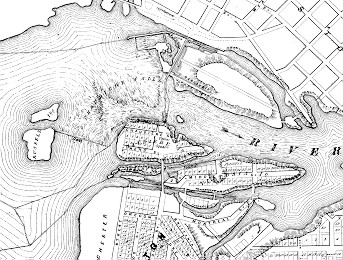
The map shown here is a detail from the Historical Atlas of Carleton County, Ontario of H.Belden and Co. 1879. Examine the complicated system of dams, barrages, booms, and wharfs to the southwest of the main falls.
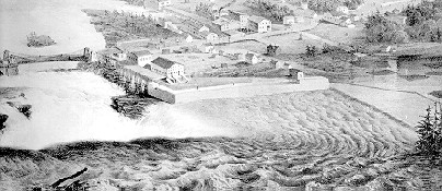
This bird's eye view is from City of Ottawa, Canada West. Lithograph by Sarony, Major and Knapp after drawing by Stent and Laver, Architects, New York. c.1859. The suspension bridge is at the back left. At the right there are timber rafts drifting towards the slide guided by log booms. At the right side in the middle there is what looks like a very straight underwater ledge connecting between Chaudiere Island and Russell Island at the lower right. This is the "government dam", an under water barrage, built to reduce the current pull on the rafts towards the falls.
In the centre of the picture is a long "L"-shaped wharf in front of a mill built to keep the water levels up to the mill. Now let's zoom in to the flat structure to the left of the mill.
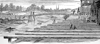
Frank Leslie's Illustrated Newspaper, September 29, 1860 from a sketch by Robert. E. Creasey Workers sorting logs in the basin. The house above the stone arch is noted as belonging to "C. Wright Esq." This house, known as "Prospect Hall", built about 1858, was the home of Charles B. Wright, son of Ruggles. Charles looked after the manufacture of concrete at the Chaudiere until the fire of of 1900. His daughter Rosina wrote a vivid story about that event. The little bump to the left of St. Patrick's Basilica was the "La Champagne Hotel."
 Frank Leslie's Illustrated Newspaper, September 29, 1860.
Artist Robert. E. Creasey.
A view of walkway wall further along.
The caption says
"This sketch is taken from the rear of Patty's Mills, and shows
the natural and striking curiosity, the 'Big Kettle', into which
the Ottawa pours and roars and boils. In the distance is seen
Hull in Canada East."
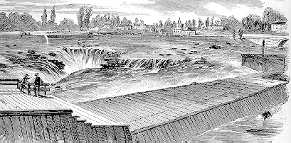
Frank Leslie's Illustrated Newspaper, September 29, 1860.
Artist Robert. E. Creasey.
A view of walkway wall further along.
The caption says
"This sketch is taken from the rear of Patty's Mills, and shows
the natural and striking curiosity, the 'Big Kettle', into which
the Ottawa pours and roars and boils. In the distance is seen
Hull in Canada East."
