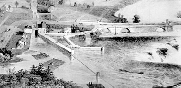
The entrance to the Hull slide. This detail from City of Ottawa, Canada West. Lithograph by Sarony, Major and Knapp after drawing by Stent and Laver, Architects, New York. c.1859. Rafts are floating towards the crib slide. The purpose of the triangular basin to the right of the crib entrance seems to be for feeding water into the mill building. The water would push through to a channel leading below the falls.
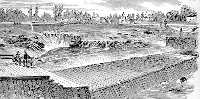 Frank Leslie's Illustrated Newspaper, September 29, 1860.
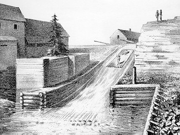
A view of walkway wall beside the Hull slide entrance.
The sketch was made "from the rear of Patty's Mills" by artist
Robert. E. Creasey. The best place to view the Eddy wharf
where the slide began is from the public park just
west of Eddy Paper Mill "B" (building 14).
Frank Leslie's Illustrated Newspaper, September 29, 1860.
A view of walkway wall beside the Hull slide entrance.
The sketch was made "from the rear of Patty's Mills" by artist
Robert. E. Creasey. The best place to view the Eddy wharf
where the slide began is from the public park just
west of Eddy Paper Mill "B" (building 14).
Ruggles Wright built his crib slide along side what is now Laurier Avenue. It was the first timber slide in the country capable of passing full cribs. Competition from Bronson's slide more or less drove Wright into bankruptcy. The west-most part of it, 30 feet across and fifteen feet deep, was excavated through solid rock until connected with a natural channel that existed between Philemon Island and Hull. The government purchased it in 1851 at which time it was supplying water power to three establishments. The last timber passed through it in 1929 a century after it was first built as a kind of Centennial celebration. The Hull slide was also called the Ruggles Wright or North Chaudière slide.
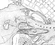 Map of Chaudiere falls area by W.A. Austin.
Lithographed by J. Ellis, Toronto. c. 1857
The channel of the slide is seen between Hull
and what was Philemon Island. Notice two-part Russell Island
just west of the falls which is not there any more.
A maze of log booms guide the logs away from the falls and into
the slides. The Hull slide:
Map of Chaudiere falls area by W.A. Austin.
Lithographed by J. Ellis, Toronto. c. 1857
The channel of the slide is seen between Hull
and what was Philemon Island. Notice two-part Russell Island
just west of the falls which is not there any more.
A maze of log booms guide the logs away from the falls and into
the slides. The Hull slide:
- began at the Eddy wharf behind the Eddy Paper Mill "B",
- then ran through the drive between that building and the water turbine building (18), and across Eddy street,
- along Laurier street between Eddy and Maisonneuve just in front of the factories,
- across Maisonneuve under the bridge just to the south of the lights,
- through the field south of the bicycle path,
- out to a small hidden bay around the corner west from the rocky outcrop over the river.
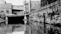 A 1950's'ish photo showing the Hull Slide running between
two building of the E.B. Eddy plant and crossing Eddy Street.
A 1950's'ish photo showing the Hull Slide running between
two building of the E.B. Eddy plant and crossing Eddy Street.
It is all filled in now with indifferent rubble. There are some steam pipes installed in the the old trench along Laurier until Maisonneuve. The slide curved off south of the bicycle trail and didn't follow it down through the underpass. After the slide was filled up Philemon Island, which is still shown on some maps, ceased to exist as an island. Where the bicycle path comes up to Maisonneuve there is a stone mill wheel used for grinding wood into pulp half buried in the grass.
 A sketch showing the exit of the Hull slide from
The best place to view the exit into the Ottawa river is from Victoria
Island behind the Carbide Mill. The slide exit was inconveniently
split by an small island and the slide proper used to exit on the west
side of that island. That west exit is filled in right to the
river with rock. The east side of the island is still open a
bit and makes a small picturesque bay beside a rock buff. The
end of that bay, hidden from the observer on Victoria Island,
has also been filled in with rock and logging debris.
A sketch showing the exit of the Hull slide from
The best place to view the exit into the Ottawa river is from Victoria
Island behind the Carbide Mill. The slide exit was inconveniently
split by an small island and the slide proper used to exit on the west
side of that island. That west exit is filled in right to the
river with rock. The east side of the island is still open a
bit and makes a small picturesque bay beside a rock buff. The
end of that bay, hidden from the observer on Victoria Island,
has also been filled in with rock and logging debris.
The last picture shows the exit of the Hull timber slide. Lithograph by W.S. Hunter Jr., from Hunter's Ottawa Scenery, engraved by J.P. Newell, Boston, 1855.
