![]() 01 -- Booth Board
Mill/Usine de Planches Booth (1912, 1918, 1928)
01 -- Booth Board
Mill/Usine de Planches Booth (1912, 1918, 1928)
This building is an amazing monument of industrial architecture. Its made of poured concrete and resembles a fantastic medieval fortress more than a factory. The walls crawl around the rocky edge of the island and seem to bend and poke out where ever a tank or process demanded it.
Although the architectural design may be criticized for being excessively austere it is not entirely without ornament. There is a decorative coping band around the roof level. Also since the building was abandoned many of the windows were bricked up and this hides an important architectural element in the original design. It is one of a few buildings on the island built in this distinctive Chaudiére style and a glance around will reveal that the boiler room and Eddy Ottawa powerhouse #1 have the same all concrete construction with the same coping band at the roof. Its a particular style and requires a bit of sustained attention to learn to appreciate its subtlties. This "Boothian" design includes windows with no lindels and usually a slight angular gable giving the building, if you coax it long enough, a vaguely Doric look.
 02 -- Booth Steam Plant/Chaudières
Booth (1906)
02 -- Booth Steam Plant/Chaudières
Booth (1906)
The steam plant is in two parts. The oldest part is south
behind the security office. In front of this older part is the concrete
base remaining from the original 175 foot high smokestack. It was built
in 1905-06 to generate steam for use in the fine paper and newsprint operation
J.R. Booth decided to set up at the age of 77. It used to house 13 Babcox
and Wilcox -type straight-tube boilers. The
current E.B. Eddy steam plant is just in front of it .
03 -- Booth Groundwood Pulp
Mill #1/Usine de pâte Booth #1 (1900-1904)
The passerby should notice the fancy brickwork on this building above the windows and doors and along the roof only on the side facing Chaudière Street. It was built excessively close to the sidewalk - actually outside of the property limits that Booth leased. It was very much his style to push and tresspass over the limits of his leaseholds where ever it was expedient for him and so it is doubtful that he asked permission to do this.
The most interesting part of this brick building is the de-watered channel beside it on the south. This channel, now obstructed by trees and bushes, used to be filled with water from the Buchanan channel across the road which ran the water wheels which worked the mill. Behind the pulp mill from top of the bulkhead at the end of the channel one can see the various deflectors and chutes with which the water was controlled. A nice view of O.H. Power House #4 is also available from behind it.
04 -- Booth Office/Bureau Booth
(1900)
05 -- Booth Stables/Ecuries
Booth (1900)
06 -- Booth Stores and Blacksmith
Shop/Magasins et forge Booth (1900)
These three buildings were built to replace others destroyed in the great fire of 1900. The careful observer can see the old stone foundations from the pre-fire buildings that were reused as the foundation for the current red brick walls.
The E.B. Eddy Engineering offices and stores are here now and there is not much to look at for the casual passer-by yet these are the offices, a few still having the original pine paneling. If you go slightly down the driveway you can see the wide carriage and stable doors which are suggestive of the previous incarnation where the stables held almost 100 horses (mostly Clydesdales) and the blacksmiths operated 16 forges where they made boom chains, tools, brackets, sleigh runners, pickerons, pike poles, and pivies.
07 -- Bronson Office/Bureau
Bronson (1880, 1900)
The red brick building was made in 1880, the additional stone building was built in 1900. This was the Bronson Company Head office. The building is currently rented to the Ottawa-Hull Naval Association and used as a bar and lounge. It is open to the public for lunch.
08 -- Bronson Pulp Mill/Usine
de pâte Bronson
A visit here is a worthwhile detour but it is difficult to get to without making a specific tour. Basically you go to visit "The Mill" Restaurant, but rather than visiting the restaurant, you park there and look at the remains of the old Bronson pulp mill. There are some stairs down to the water, great stone arches and remains, ruins, remains of sluices, great iron mill wheels and pipes and cranks, the sound of running water all over the place.
![]() 09 -- Carbide
Mill/Usine de carbure (1899)
09 -- Carbide
Mill/Usine de carbure (1899)
Construction for the great Carbide mill started in 1899. It survived the great fire of 1900. In October 29, 1901 there was an explosion in the mixing room that killed one man. Its later history is mixed. From 1944-45 the RCAF Photographics and Records Section was located there.
![]() 10 -- Bronson
Channel
10 -- Bronson
Channel
![]() 11 -- O.H.E.C
Channel
11 -- O.H.E.C
Channel
![]() 12 -- Buchanan
Channel
12 -- Buchanan
Channel
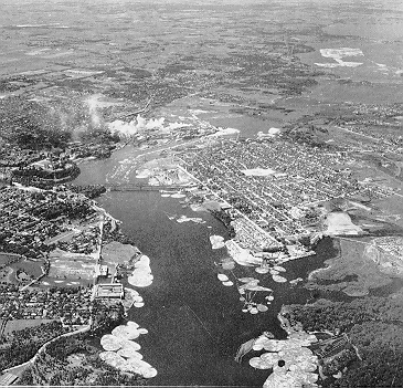
From Hurling Down the Pine: "The great mass of the river tumbling over the main casade seemed untameable, at least by private enterprise. The government of the province of Canada stepped in. A diversion dam and flumes were built, to carry some of the water from the falls down past newly laid-out mill sites on 21 year leases. The works were completed by 1853 and the Americans were waiting, ready to start building on the "hydraulic lots". Captain Levi Young, a New Englander, had arrived in 1851. The next year came Captain J.J. Harris amd H.F. Bronson from Painted Post, New York. W.G. Perley and C.B. Pattee arrived soon afterwards."
The Bronson Channel (10) feeds the Ottawa Hydro Power Plant #2, (32) which is at its far end, and was also the entrance for the Victoria Island crib slide (27). When the channel is occasionally emptied for repairs in the summer and at the bottom one can see what looks like a wood planked covered corridor dug into the bottom of the channel and leading to the hydro plant. This covered corridor is likely an engineering artifact which improves the water head to the hydro turbines. There is a flat stone covered ramp leading to the slide entrance. After the building of the ring dam, the water level rose up there was a kind of lock built to allow the slide to operate but I can not find any trace of that.
The OHEC Channel (11) feeds the The Ottawa Hydro Power House #4 (33) via a flume covered by a concrete roof. The flume and its cover is visible from the sidewalk. In the middle of this channel, just beside the E.B. Engineering offices, was a quaintly named Coffin Island. The Buchanan Channel (12) used to feed the waterworks of the Booth Groundwood Pulp Mill #1 (03), the brick building just across the street, as well as some earlier mill set up by there by Buchanan maybe decades before the fire.
13 -- Chaudière Bridge
The Union Bridge and its successors
- 1828 Wooden arch (Collapsed in 1835)
- 1843 Suspension bridge
- 1889 Steel truss bridge
- 1920 Steel truss bridge (Current bridge)
In 1928 a series of stone and wooden bridges across the Chaudière Falls were built under the direction of Lt. Colonel John By. The new bridges would make it easier to bring supplies in from Montreal to support the construction of the Rideau Canal which was just starting.
Over the main channel of the river was built a wooden arch bridge. This bridge was replaced in 1843 with a suspension bridge which looked a bit like a rustic version of the Brooklyn or San Francisco bridge. The new bridge had stone tower piers holding the suspension cables and a wagonway stiffened by wooden trusses. The suspension bridge was only 20 feet wide and soon inadequate for the traffic it carried. This bridge was then replaced in 1889 by the "Old Union Bridge", a steel truss bridge built by Messis, Rousseau and Mather. By 1914 the Old Union bridge was considered too weak for the loads it had to carry and in 1919 a contract was awarded to the Dominion Bridge company of Lachine Quebec to build the current bridge and abutments.
 A
W.H.Bartlett print published in 1940 showed the first wooden truss Union
bridge, and a second wooden truss bridge between Victoria Island and Amelia
Island on the Ontario side along with four stone arches on the Québec
side. Parts of these 1828-43 stone arch bridges still remain as supporting
structures to the current bridge and are among the most important monuments
of the heroic era in Ottawa. A full stone arch from 1928 exists hidden
under the Eddy bridge at the traffic lights in front the Eddy truck entrance.
A
W.H.Bartlett print published in 1940 showed the first wooden truss Union
bridge, and a second wooden truss bridge between Victoria Island and Amelia
Island on the Ontario side along with four stone arches on the Québec
side. Parts of these 1828-43 stone arch bridges still remain as supporting
structures to the current bridge and are among the most important monuments
of the heroic era in Ottawa. A full stone arch from 1928 exists hidden
under the Eddy bridge at the traffic lights in front the Eddy truck entrance.
*** What follows is a very important thing to do on your
tour ** Wait at the Eddy truck entrance around building 20 until the lights
change and go to the raised walled open area that divides the traffic flow.
The stone arch may be seen inside there. Now shoot across to the other
side of the road into the driveway into the Hydro Québec Generator
#2 building a little to the south and west. (Make sure you are at where
the Hydro Québec #2 sign is, and not at the entrance to the Eddy
plant.) Here is a different view of the same arch, plus looking south,
a view of a different stone arch being the foundation of the current Union
(Chaudière) bridge. A different view may be had from the north-north-west
corner of the board mill - building 1.
![]() 14 -- Eddy
Paper Mill "B" and Storehouse
14 -- Eddy
Paper Mill "B" and Storehouse
![]() 15 -- Eddy
Paper Mill "A"
15 -- Eddy
Paper Mill "A"
![]() 16 -- Eddy
Box Shop
16 -- Eddy
Box Shop
![]() 17 -- Eddy
Hull Power House (1913)
17 -- Eddy
Hull Power House (1913)
This fully operational powerhouse provides power for Eddy's operations. It is built of re-inforced concrete. The picturesque gully in front of it, of which various mysterious stories exists and which is well worth the dash across the road, is called the Devil's Hole.
![]() 18 -- Eddy
Mechanical Water Turbine
18 -- Eddy
Mechanical Water Turbine
![]() 19 -- Eddy
Old Beater Mill
19 -- Eddy
Old Beater Mill
![]() 20 -- Eddy
Old Finishing Mill
21 -- Eddy Old Match Factory
(1901)
20 -- Eddy
Old Finishing Mill
21 -- Eddy Old Match Factory
(1901)
Eddy hasn't made matches at the Chaudière since the late 1920's.
![]() 22 -- Eddy
Old Pail Factory (1900)
22 -- Eddy
Old Pail Factory (1900)
![]() 23 -- Eddy
Old Pail Factory (1900)
23 -- Eddy
Old Pail Factory (1900)
Both are built from grey stone. Building 23, may be seen from the E.B. Eddy truck entrance at the traffic lights on Eddy street and it's worthwhile to be able to spot it. Building 22, on the other hand, is mostly enclosed by another Eddy building constructed around it. A stone wall from it is visible from behind the fence at the intersection of the Portage bridge and Laurier but it is hardly worth the detour to look at it. Before 1920 the Eddy company used to manufacture a wide range of household products at the Chaudière and these buildings used to house operations to make pails, washboards, indurated ware and pressed woodchip pails.
![]() 24 -- Eddy
Ottawa Power House #1
24 -- Eddy
Ottawa Power House #1
Notice the old style steel tower supporting the high voltage wires coming from this building. There is a round green tank behind it.
![]() 25 -- Eddy
Ottawa Power House #2
25 -- Eddy
Ottawa Power House #2
![]() 26 -- Hull
Crib Slide/Glissoire de crib Hull (1829)
26 -- Hull
Crib Slide/Glissoire de crib Hull (1829)
Ruggles Wright built his crib slide along side what is now Laurier Avenue. It was the first timber slide in the country capable of passing full cribs. The west-most part of it, 30 feet across and fifteen feet deep, was excavated through solid rock until is connected with a natural channel that existed between Philemon Island and Hull. The government purchased it in 1851 at which time it was supplying water power to three establishments. The last timber passed through it in 1929 a century after it was first built as a kind of Centennial celebration. The Hull slide was also called the Ruggles Wright or North Chaudière slide.
The slide
- began at the Eddy wharf behind the Eddy Paper Mill
"B",
- then ran through the drive between that building and
the water turbine building (18), and across Eddy street,
- along Laurier street between Eddy and Maisonneuve just
in front of the factories,
- across Maisonneuve under the bridge just to the south
of the lights,
- through the field south of the bicycle path,
- out to a small hidden bay around the corner west from
the rocky outcrop over the river.
The best place to view the Eddy wharf where the slide began is from the public park just west of Eddy Paper Mill "B" (building 14). The best place to view the exit into the Ottawa river is from Victoria Island behind the Carbide Mill. The slide exit was inconveniently split by an island and the slide proper used to exit on the west side of that island. That west exit is filled in right to the river with rock. The east side of the island is still open a bit and makes a small picturesque bay beside a rock buff. The end of that bay, hidden from the observer on Victoria Island, has also been filled in with rock and logging debris.
27 -- Bronson Slide/Glissoire
Bronson
The metal flume (1970) now found off the Bronson channel is on the same site as the crib slide built in 1832 by John Buchanan. Buchanan built his slide in direct competition from the Wright slide and by eight years later had won over most of the business from Wright's slide due to its superior location. The Bronson slide was the most important station on the Ottawa River. By 1874 all square timber cribs passed through it and the Hull slide was used for saw logs alone.
The government revoked the Buchanan's lease on the Chaudière property from Buchanan's widow Mrs. Caroline R. Thomson taking over Bronson slide in 1845 and then bought the Hull slide from Ruggles Wright in 1851. Both were operated by the government and both of the two were sometimes referred to as the government slide in the years after this.
In May 1850 H.Merrill, Superintendent of the Ottawa River Works, reported 300-500 cribs a day passing the Chaudière slides. In 1852, 15,600 cribs had passed through the slides "with 22 rafts still not counted" along with in 1865 200,000 saw logs. All passed through into the retaining boom for use by the many saw mills along the river. Both government slides suffer severely in the fire of April 26, 1900. Extensive repairs were needed after the fire and considerable debris were removed.
The crib ride was a great Canadian ride and visitors could go and be entertained by the cribs, steered by expert raftsman, go down the slide. The slide area also provided a magnificent view of the new Parliament buildings. Edward, Prince of Wales was given a ride down the crib slide in 1860. The Duke and Duchess of York went down the slide in 1901. An old photograph shows how benches were put on the crib for the regal couple and a flotilla of river boats greeted them at the bottom when they arrived.
The best place to view the old slide area and the new
metal log flume is through the trees behind the public parking lot in front
of buildings 31 and 34 on Victoria Island. It's a nice view of an historic
area, but the old slide is totally rotted away.
28 -- Hydro Québec #1
Old grey stone building.
29 -- Hydro Québec #2
Modern Louis XVI type building.
30 -- Ottawa Electric Railway
Company Hydro Ruins/Ruines hydro (1891)
These interesting and impressive ruins point to a long
abandoned concrete, brick and steel structure. The concrete structures
are quite monumental in their own way. A large tree grows out through the
middle of the ruins seemly emphasizing the transitory essence of human
endevours. A once great operational hydro plant is now "abandoned and in
complete ruins, overgrown with vegetation; seepage in the retaining walls;
ground covered with debris." (Olga Budimiromic - 1982) In front of you
is the raised O.H.E.C company covered flume going to O.H. power plant #4.
31 -- Ottawa Electric Railway
Company Steam Plant/Usine thermique (1915)
This red brick building used to be a generating plant for the Ottawa Electric Railway. A local bus tour company uses it now to store its buses. Make sure you walk across the parking lot here in front here and look at the channel for the old crib slide behind the trees. There are some public washrooms here.
32 -- Ottawa Hydro Power House
#2/Centrale Ottawa Hydro #2 (1891)
This power plant is located on what was used to be Amelia Island. The AC generators here were built by Westinghouse in 1914 and the other equipment is of similar vintage. The plant is run by Ottawa Hydro and the power fed into the Ottawa city power grid.
33 -- Ottawa Hydro Power House
#4/Centrale Ottawa Hydro #4
This is an interesting little limestone station. The AC generators were built by Canadian General Electric around 1900 and there is some other equipment is of similar age. The water supply here is unfortunately a bit sparse and with more water it could easily provide twice the output it does. It is used mostly for supplemental power during periods of peak demand. The equipment is all paid for, it only needs a couple of workers to look after it, so it is relatively cheap to maintain. The best view of the power house is from behind the Booth groundwood pulp mill #1 (building 03) across the channel. A funky little mobile crane on rails inside a wooden shed assists in the maintenaince of the power plant.
34 -- Ottawa Hydro Wooden Shed/Remise
en bois Ottawa Hydro
In the old days the island would have many sheds much this this one around serving as workshops or storehouses. Some old turbine parts are thoughtfully displayed on the grass outside of it for the consideration of visitors.
35 -- Ring Dam/Barrage en hémicycle
(1907-1909)
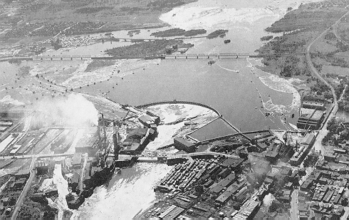
The dam was built to raise the level of water feeding the Chaudière operations, and to allow precise control over this water level for users. The circular arc layout gives a very strong overall structure to hold back water and ice.
Construction on the ring dam was initiated by the Chaudiere Water Power Owners and Lessee's in 1906. The names of the members with their portions of interest were as follows - from Ontario: John R. Booth (10/60), The Ottawa Electric Company (6/60), The Ottawa Electric Railway Company (3/60), Ottawa River Power Company (5/60), The Bronson Company (5/60), The Ottawa Investment Company (1/60); - from Quebec: E.B. Eddy Company Ltd (10/60), and the Ottawa-Hull Power and Manufacturing Company (20/60). Half the interest was from Quebec and half from Ontario. By 1966 the owners and their portions of interest were - from Ontario: Ottawa Hydro (17/60), E.B. Eddy Company (Ontario) (13/60); - from Quebec: E.B. Eddy (Quebec) (10/60), Hydro Quebec (20/60) and these principals still share responsibilities for managing the dam, maintaining and setting water levels.
The original water surface was approximately 48.0 feet above datum (Ottawa datum was the top of sill of Rideau Canal Lock #1). By 1920 after the dam was built the water level had raised four feet to 52.0 and a few islands, both real and artificial were submerged. Even during periods of low water, there is about 2,200 cubit feet per second passing by the Chaudière and in the spring there can be three times as much as this.
Outside west of the ring dam are small islands with what looks like overturned concrete huts on them. They were used to anchor log booms which guided the timber cribs down to the crib slide. This web of booms and dams was very complex.